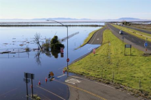
Recognizing the massive values at stake along US shorelines from sea level rise, we developed new approaches for tracking shoreline changes. With support from the Center for Transportation, Environment, and Community Health (CTECH), we adapted newly emerging UAV-based elevation mapping to use on shorelines, in order to conduct high spatial and temporal resolution tracking of infrastructure and shoreline conditions. We combined this approach with RTK-GPS (real-time kinematic geo-positioning systems) field measurements to create a multi-scale picture of shoreline change due to sea level rise. Research products included: 1) a demonstration of high-resolution terrain-mapping methods for quantifying shoreline flooding event impacts on coastal infrastructure and adjacent ecosystems, and 2) description of how this information could be used to validate sea level rise models and inform coastal hazard-adaptation planning for shoreline infrastructure.
Tracking Shoreline Conditions to Protect Infrastructure
Project Status
Completed Project
Program

