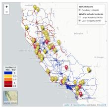
Real-time Deer Incidents & Wildlife-Vehicle Conflict (WVC) Hotspots map, with live data feeds from the California Roadkill Observation System (CROS) and the California Highway Incident Processing System (CHIPS).
![]() Animal observed less than 7 days ago.
Animal observed less than 7 days ago.
![]() CHP Incident happened less than 24 hours ago.
CHP Incident happened less than 24 hours ago.
![]() CHP Incident happened less than 7 days ago.
CHP Incident happened less than 7 days ago.
Map Tips
- Click on the plus (+) or minus (-) buttons—or use the mousewheel—to zoom in and zoom out of the map.
- Use the "Map Layers" on the right to select which map layers to show.
Data Sources
WVC Hotspots - Wildlife-vehicle conflict information from the California Highway Patrol (CHP) was combined with carcass data from the California Roadkill Observation System (CROS).
Highway Hotspots - If you select this map and click on highway segments, an information box will appear with additional details about the road segment, including count of including count of incidents per mile, per year.
Incident Clusters - This map indicates highway segments that have statistically-significant clusters of incidents.
Large Mammals (CROS) - These data come from the California Roadkill Observation System (CROS), which is queried every 15 minutes to show near real-time wildlife-vehicle collisions (WVC). These data will remain on the map for one week.
![]() Orange markers indicate animal observed less than 7 days ago.
Orange markers indicate animal observed less than 7 days ago.
Deer Incidents (CHP) - These data are from the California Highway Patrol (CHP) and are collected into a private database known as "CHIPS" that is managed by the Road Ecology Center. These data are also queried every 15 minutes, and the data are retained for one week.
![]() Red markers indicate incident happened less than 24 hours ago.
Red markers indicate incident happened less than 24 hours ago.
![]() Yellow markers indicate incident happened less than 7 days ago.
Yellow markers indicate incident happened less than 7 days ago.

